Saturday, 17 September 2011
Saturday, 18 June 2011
Dead sea scroll about the bible
  |
1.The Dead Sea Scrolls were discovered in eleven caves along the northwest shore of the Dead Sea between the years 1947 and 1956. The area is 13 miles east of Jerusalem and is 1300 feet below sea level. The mostly fragmented texts, are numbered according to the cave that they came out of. They have been called the greatest manuscript discovery of modern times. See a Dead Sea Scroll Jar. 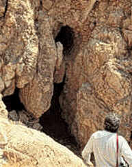 2. Only Caves 1 and 11 have produced relatively intact manuscripts. Discovered in 1952, Cave 4 produced the largest find. About 15,000 fragments from more than 500 manuscripts were found. 3. In all, scholars have identified the remains of about 825 to 870 separate scrolls. 2. Only Caves 1 and 11 have produced relatively intact manuscripts. Discovered in 1952, Cave 4 produced the largest find. About 15,000 fragments from more than 500 manuscripts were found. 3. In all, scholars have identified the remains of about 825 to 870 separate scrolls. 4. The Scrolls can be divided into two categories—biblical and non-biblical. Fragments of every book of the Hebrew canon (Old Testament) have been discovered except for the book of Esther. 5. There are now identified among the scrolls, 19 copies of the Book of Isaiah, 25 copies of Deuteronomy and 30 copies of the Psalms . 6. Prophecies by Ezekiel, Jeremiah and Daniel not found in the Bible are written in the Scrolls. 7. The Isaiah Scroll, found relatively intact, is 1000 years older than any previously known copy of Isaiah. In fact, the scrolls are the oldest group of Old Testament manuscripts ever found. 8. In the Scrolls are found never before seen psalms attributed to King David and Joshua. 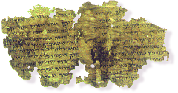 9.There are nonbiblical writings along the order of commentaries on the OT, paraphrases that expand on the Law, rule books of the community, war conduct, thanksgiving psalms, hymnic compositions, benedictions, liturgical texts, and sapiential (wisdom) writings. 9.There are nonbiblical writings along the order of commentaries on the OT, paraphrases that expand on the Law, rule books of the community, war conduct, thanksgiving psalms, hymnic compositions, benedictions, liturgical texts, and sapiential (wisdom) writings. 10. The Scrolls are for the most part, written in Hebrew, but there are many written in Aramaic. Aramaic was the common language of the Jews of Palestine for the last two centuries B.C. and of the first two centuries A.D. The discovery of the Scrolls has greatly enhanced our knowledge of these two languages. In addition, there are a few texts written in Greek. 11. The Scrolls appear to be the library of a Jewish sect. The library was hidden away in caves around the outbreak of the First Jewish Revolt (A.D. 66-70) as the Roman army advanced against the rebel Jews. 12. Near the caves are the ancient ruins of Qumran. They were excavated in the early 1950's and appear to be connected with the scrolls. 13. The Dead Sea Scrolls were most likely written by the Essenes during the period from about 200 B.C. to 68 C.E./A.D. The Essenes are mentioned by Josephus and in a few other sources, but not in the New testament. The Essenes were a strict Torah observant, Messianic, apocalyptic, baptist, wilderness, new covenant Jewish sect. They were led by a priest they called the "Teacher of Righteousness," who was opposed and possibly killed by the establishment priesthood in Jerusalem. 14. The enemies of the Qumran community were called the "Sons of Darkness"; they called themselves the "Sons of Light," "the poor," and members of "the Way." They thought of themselves as "the holy ones," who lived in "the house of holiness," because "the Holy Spirit" dwelt with them. 15. The last words of Joseph, Judah, Levi, Naphtali, and Amram (the father of Moses) are written down in the Scrolls. 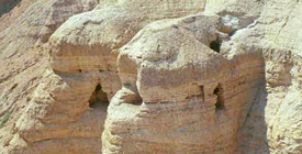 16. One of the most curious scrolls is the Copper Scroll. Discovered in Cave 3, this scroll records a list of 64 underground hiding places throughout the land of Israel. The deposits are to contain certain amounts of gold, silver, aromatics, and manuscripts. These are believed to be treasures from the Temple at Jerusalem, that were hidden away for safekeeping. 16. One of the most curious scrolls is the Copper Scroll. Discovered in Cave 3, this scroll records a list of 64 underground hiding places throughout the land of Israel. The deposits are to contain certain amounts of gold, silver, aromatics, and manuscripts. These are believed to be treasures from the Temple at Jerusalem, that were hidden away for safekeeping. 17. The Temple Scroll, found in Cave 11, is the longest scroll. Its present total length is 26.7 feet (8.148 meters). The overall length of the scroll must have been over 28 feet (8.75m). 18. The scrolls contain previously unknown stories about biblical figures such as Enoch, Abraham, and Noah. The story of Abraham includes an explanation why God asked Abraham to sacrifice his only son Isaac. 19. The scrolls are most commonly made of animal skins, but also papyrus and one of copper. They are written with a carbon-based ink, from right to left, using no punctuation except for an occasional paragraph indentation. In fact, in some cases, there are not even spaces between the words. 20. The Scrolls have revolutionized textual criticism of the Old Testament. Interestingly, now with manuscripts predating the medieval period, we find these texts in substantial agreement with the Masoretic text as well as widely variant forms. 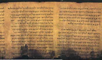 21. Some of the Dead Sea Scrolls actually appeared for sale on June 1, 1954 in the Wall Street Journal. The advertisement read — "The Four Dead Sea Scrolls: Biblical manuscripts dating back to at least 200 BC are for sale. This would be an ideal gift to an educational or religious institution by an individual or group. Box F206." 21. Some of the Dead Sea Scrolls actually appeared for sale on June 1, 1954 in the Wall Street Journal. The advertisement read — "The Four Dead Sea Scrolls: Biblical manuscripts dating back to at least 200 BC are for sale. This would be an ideal gift to an educational or religious institution by an individual or group. Box F206." 22. Although the Qumran community existed during the time of the ministry of Jesus, none of the Scrolls refer to Him, nor do they mention any of His follower's described in the New Testament. 23. The major intact texts, from Caves 1 & 11, were published by the late fifties and are now housed in the Shrine of the Book museum in Jerusalem. 24. Since the late fifties, about 40% of the Scrolls, mostly fragments from Cave 4, remained unpublished and were unaccessible. It wasn't until 1991, 44 years after the discovery of the first Scroll, after the pressure for publication mounted, that general access was made available to photographs of the Scrolls. In November of 1991 the photos were published by the Biblical Archaeological Society in a nonofficial edition; a computer reconstruction, based on a concordance, was announced; the Huntington Library pledged to open their microfilm files of all the scroll photographs. 25. The Dead Sea Scrolls enhance our knowledge of both Judaism and Christianity. They represent a non-rabbinic form of Judaism and provide a wealth of comparative material for New Testament scholars, including many important parallels to the Jesus movement. They show Christianity to be rooted in Judaism and have been called the evolutionary link between the two. 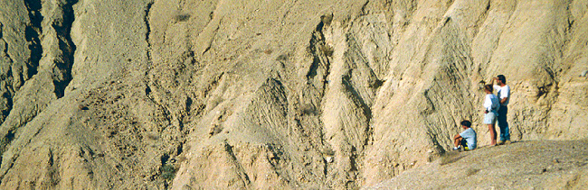 The rugged terrain of the Qumran area. The rugged terrain of the Qumran area. |
Thursday, 16 June 2011
NOAH ARK
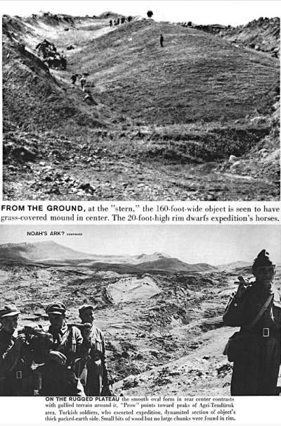
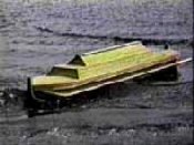
In September 1960, 27 year-old Ron Wyatt, along with thousands of other people, read the following article in Life Magazine about an exciting boat-shaped formation in the region of eastern Turkey named Ararat:
"NOAH'S ARK?
Boat-like form is seen near Ararat 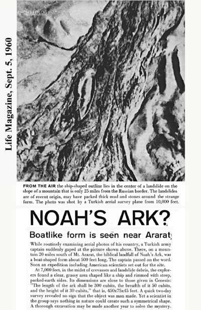
At 7,000 feet, in the midst of crevasses and landslide debris, the explorers found a clear, grassy area shaped like a ship and rimmed with steep, packed-earth sides. Its dimensions are close to those given in Genesis: 'The length of the ark shall be 300 cubits, the breadth of it 50 cubits, and the height of it 30 cubits,' that is, 450x75x45 feet. A quick two-day survey revealed no sign that the object was man made. Yet a scientist in the group says nothing in nature could create such a symmetrical shape. A thorough excavation may be made another year to solve the mystery." LIFE
Ron's Decision is Made At that time, Ron determined that one day, he would visit the site and see it for himself. But that was a dream he could scarcely realize anytime soon. He had a sixteen month-old daughter, a three month-old son, and within thirteen months, he would have another son. He was working as a lab technician in the quality control lab at Hercules Powder Plant in Kalamazoo, Michigan, and also attending Western Michigan University studying pre-med.
But soon family matters forced him to give up his hopes of becoming a doctor and he moved to Kentucky in 1964, where he entered nursing school. He graduated in 1967, and entered anesthesia school and graduated as a Certified Registered Nurse Anesthetist in 1970. It was also in 1970, that he found himself raising his three young children alone.
It didn't look like there would ever be any opportunity for him to visit the boat-shaped site, so he had to limit his archaeological research to libraries and book stores. But he never lost interest -- in fact, he studied everything concerning ancient history and archaeology, not just subjects concerning Noah's Ark.
He had found that there was very little information available on the subject of Noah's Ark, which convinced Ron more than ever that no serious research had ever been undertaken on the subject. Everything he had read was based on folklore and unsubstantiated claims, and all the sightings were in different locations.
He continued this experiment with several shapes with the same result each time. That is, until he built a crescent-shaped formation, with the crescent concave side facing down-stream. When the boat accelerated around this crescent-shaped mountain, he saw that it was pulled into the area within the crescent by the eddy effect, whereupon it gently floated within that area.
With this bit of information, Ron felt like the ark would have harbored in such a location. The laws of hydrodynamics and water action and reaction were the same then and now. If the ark had approached a mountain peak extending out of the water, the water displacement around the mountain would have carried the ark with it.
The study of water as a fluid, with its unique properties, and the study of hydrodynamics (fluid mechanics) and wave causation and motion is a most involved and complicated science. The actions and reactions of water and an object floating on that water cannot possibly be studied in-depth here -- but some simple rules must be understood.
If your ship on the open sea approaches a mountain extending out of the ocean, only one of two things can happen:
The necessary criteria for a ship to land on a mountainside as sea waters descended, would involve a process by which the water displacement would trap the ship within an area, such as an eddy could do. At least, that's what Ron believed and later found to be true, based upon the formation of the mountains at the ark site.
And as he mulled over all the information in his mind, there was one thing that seemed to be obvious to him: He knew that Moses had been the author of the Genesis account and therefore the flood story - and as such, Ron believed that the type of cubit Moses would have been accustomed to, would have been the Royal Egyptian Cubit, the most universal standard of measurement in the ancient world at that time. There was no Hebrew Cubit in existence during Moses' time, and to Ron, the 500 foot measurement given in the Life article was even more compelling evidence that the site needed thorough exploration. After all, 300 Royal Egyptian Cubits equals 515 feet which is similar to the ark formation, but the Hebrew Cubit is only 450 feet and comes into existence much later after Moses.
1975- The Ark File
So, he contacted all but one of the American members of the expedition and gleaned from them everything they could tell him. When he told them he wanted to visit the site, they all basically told him he was crazy to do so. They were all adamant that nothing was there- that is, all except one man, Dr. Arthur Brandenburger who still believed it was a ship.
He asked them how to get to the site- after all, "20 miles south of Mt. Ararat" is a pretty vague location in a region that is very mountainous. But no one could tell him exactly how to get there because they had ridden on horseback for many hours to the site, while being led by the Turkish military.
It was now 17 years since he first read about the site. He told the children what he was about to do and to his dismay, the boys, Danny who had just turned seventeen, and Ronny who would be sixteen in 2 months, insisted on going too. Torn about whether to take them or not, he did the only thing he knew to do -- he said a little prayer that if the boys were supposed to go, that they would receive their passports before the departure date, AND, there would be seats available on the chartered flight from New York to Istanbul.
He had been told that he had booked the last seat on the flight, and when he called to check on availability, he was again told that none were available. It was now within a week of his departure date. But two days later, he received a call from the airline - it seemed that two seats had come open at the last minute and he was asked if he wanted them. There was still the matter of the boys getting their passports, a procedure which usually took several weeks. But in three days, Danny's was back, and the next day Ronny's arrived. Yes he wanted the seats.
Many people may find Ron's method of getting information strange, but again he did the only thing he knew to do -- he prayed about it. He told the boys to say a prayer that the taxi would stall at the place where they were to begin looking for the ark. After all, their taxi driver spoke no English, they didn't know if anyone in the town could speak English -- and even if they did, would anyone know where this boat-shaped object was? It had been seventeen years since the expedition had come there- perhaps the townspeople had forgotten all about it.
Full of excitement at seeing their prayers answered, they all three climbed out of the taxi and piled a great number of rocks on the side of the road as a marker, while the bewildered driver peered under the hood of the taxi. When they all got back in the taxi, it started up and they continued on down the road.
Soon it stalled again. With a little bit less enthusiasm, they again piled up rocks on the roadside. Again, the taxi started up when they all got back in. Finally, it stalled again, and thinking that perhaps they had just gotten a defective taxi, they each placed one rock in a pile along the side of the road. This done, they headed to the hotel.
It was late when they arrived at the Erzurum Hotel in Dogubeyazit. They all fell asleep, completely exhausted from their long journey. The next morning, they hired another taxi and headed back to the third and closest pile of rocks, where they began walking in a perpendicular direction from the road.
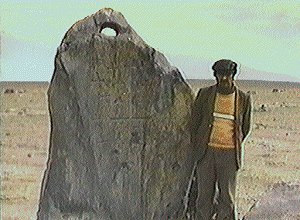
Walking over miles and miles of rugged terrain, one of the men motioned for Ron to take his photo by a very large, standing rock. Only when he looked through the viewfinder did Ron realize that this rock was identical to the ancient ship anchor stones found in the Mediterranean Sea that he had seen in archaeological books. That is, except for one thing -- this "rock" was many, many times larger!
They were all terribly excited by what they had seen, but the boat-shaped object was nowhere in sight. As they continued to walk, they showed Ron and the boys a very ancient graveyard which had strange monuments in it which looked like simple representations of a three story boat. Were these objects connected to Noah's Ark? Ron believed they were. He photographed and filmed everything with his 8mm movie camera (No video cameras back then!) and they decided to head back to the hotel for the night.
Radiating out from the house was a very large pattern of stone fences which seemed to go on for miles. These too seemed to be covered by several feet of dirt with only the upper part extending above the earth.
The Tombstones The most interesting feature of this site were the objects in the front yard -- there were two large stones, one standing upright and the other lying flat on the ground. Carved on these stones was a most exciting picture: across the top of each was an arc-shape [rainbow]; below this was a curly-cue which looked like an ocean wave, and atop it was a very simple boat-shape; walking away from this boat and wave were eight people -- the first and the largest was Noah; next and second largest was Mrs. Noah; the next three were all slightly smaller - representing the three sons of Noah; and the last 3 were slightly smaller and represented the wives of the sons.
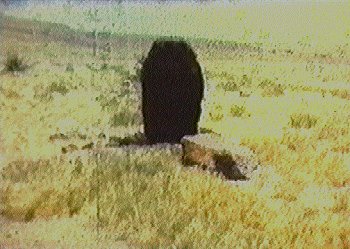
When he studied these two large monuments more closely, he noted that on the one lying on the ground, the largest woman - representing Mrs. Noah, had her eyes closed and her head tilted downward. On the larger tombstone which was still standing, he saw that BOTH the first woman AND the first man (Noah) had their eyes closed and heads tilted downward. Since these were in front of the house, he believed they were the actual tombstones of Noah and his wife!
The iconography showed that FIRST Mrs. Noah died, and on her stone only her eyes were closed. When Noah died, BOTH of them were represented as dead.
Ron felt that what he and the boys had found these first two days was extremely important. While they didn't prove anything about the boat-shaped object, there were clear indications that a family of eight people had lived in this exact area during some ancient time. The eight-cross design on the anchor stones showed that someone during the Christian era had identified these huge rocks with the ark and its eight passengers.
"Husbandry" is defined as "farming, as of livestock" (Random House Dictionary). After the flood, it makes perfect sense that Noah bred the animals and cared for them until the point in time that their numbers were sufficient enough to eliminate the likelihood of their becoming extinct. With only two of each unclean animal, if even one should not survive, that animal would become extinct. And the extremely large pattern of stone fences radiating out from the house, and extending on for a good distance seemed consistent with this type of activity. The depth below the present ground level of the house and fences shows their great antiquity. Over the years, windblown dust and dirt raised the ground level, thus burying or partially burying ancient surface structures.
This ridge had two small hills which met and formed a valley in between them on the side of this ridge. In the middle of this mountainside valley, Ron saw a VERY large square rock which looked as if it had been deliberately set in that location. Behind this large rock the valley formed a natural amphitheater. On the side of this very large rock was a complex of small fenced-in areas.
Also in this complex are two very large stones which display features which indicate that they were used for the slaughter and bleeding of animals. (Genesis. 9:4) One is consistent with the size of smaller animals like sheep and goats; the other, much larger, is consistent with the size of larger animals, such as bullocks. They both have a series of chiseled-out indentions leading from the ground to the flattened, slightly angled top. These indentions are the size that is consistent with animal hooves. Perhaps the animals were led up the side of these rocks to the top, which also contain chiseled out basins with drains, that are consistent with areas for bleeding the animals prior to offering them on the large altar stone. According to the biblical account, specific parts of the animal were offered as sacrifice, then other parts were cooked and eaten "before the Lord." (See Leviticus, chapters 1-9.)
Arising the next morning, the boys were tired and stayed in the hotel room. They had traversed across a great number of miles in the previous two days and Ron knew they needed a break. So he got a taxi and returned to the first pile of rocks. They had worked their way backwards from the third pile to the first. And this one was quite a distance from the others.
This time, Ron had the taxi driver take him as far as he could go in the direction that was perpendicular to this rock-pile. They traveled up into the mountain range to the south, as far as there was a dirt road. When it ended, Ron began to walk. With mountains everywhere, he wondered if he would ever be able to spot the boat-shaped object if he looked right at it- but soon he saw it. And what he saw convinced him more than ever that this object was the remains of a ship. But, what he saw also convinced him that there was only one way to explore its true nature, and that was by an excavation to remove the soil which covered it.
He returned to the hotel room and they packed their things. He checked out that night so they could leave early in the morning -- but that proved to be a big mistake. In 1977, there weren't any tourists to speak of in this region. It is desolate and very foreboding. The Kurdish villagers had been watching Ron and the boys, waiting to make their move. As long as they were staying in the hotel, they were spending money -- paying taxis and guides. But these bandits wanted it all, and as soon as they realized Ron was about to leave, they attacked.
It's a long story, but to summarize it, Ron and the boys heard robbers coming up the steps banging pipes and making a lot of noise. Shoving the furniture in front of the door, they tied the bed sheets together and climbed out their third story window onto a roof below. There, they climbed back into the second floor window which led into the kitchen, and they ran through the hotel and out the door.
In the commotion, they lost almost all of their film. Ron did manage to hang on to some of the movie film. Once they were safely out of town, they realized how truly dangerous the region was. The boys would never go there again -- and after all they went through, they would never see the "boat shaped object" in person.
In November of 1978, Ron finally made contact with Dr. Shea, who had written an article about the site in September 1976. He believed that the site should be thoroughly investigated, and when comparing the boat-shaped object to the current thought that the ark HAD to have landed on Mt. Ararat, wrote:
He still remembers how his heart began to pound- HE couldn't excavate, but perhaps "nature's" God had done what he couldn't!
When they arrived at the site, Ron just wasn't prepared for the spectacular sight his eyes beheld -- the earthquake (which injured no one) had dropped the earth around the object and there on the mountainside Ron saw what looked like a giant shipwreck!
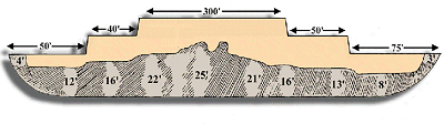
He measured the object and got a 512 foot length -- but, he saw what looked like a section about 1 yard long that was broken off from the lower end. This was positive evidence in Ron's eyes: 300 Royal Egyptian cubits were 515 feet- this object was 512 feet with a 3 foot section broken off of the lower end- a total of 515 FEET!
He again inspected the anchor stones and the graveyard which had the strange monuments which Ron believed had representations of the Ark and its eight passengers. It was a short trip, but Ron had accomplished more than he had hoped for. The next step was to have the samples analyzed.
It was another example of positive evidence -- but again, Ron found himself at a standstill.
What next? Applications to excavate were still made, but each time they returned negative replies. Ron was in for an even longer wait this time. But in the meantime, Ron decided to make all his information available to others.
Ron told the story of his two trips to Turkey, what he saw, filmed and photographed, and he gave the lab analyses and told about the tombstones he believed marked the sites of Noah and his wife's graves. He explained about the Royal Egyptian Cubit, which, considering the length of the boat shaped object, he felt was overwhelming evidence.
He gave these to anyone who was interested, hoping to gain interest and support from others who might want to help. But the fact of the matter is, this wasn't enough for some people. In fact, this little booklet would one day be responsible for the theft and destruction of one of the most incredible evidences -- but it was a lesson Ron would have to learn the hard way. Meanwhile, he had no real idea what he could do to further his research.
Ron Wyatt and Col. Jim Irwin
Jim was taking an expedition to climb Mt. Ararat in August of 1984, so he and Ron decided to travel together so that Ron could show him the site. They arrived in Istanbul on August 19, 1984 and proceeded to Ankara.
Newsletter July 1994
By Mary Nell Wyatt
Boat-like form is seen near Ararat
At 7,000 feet, in the midst of crevasses and landslide debris, the explorers found a clear, grassy area shaped like a ship and rimmed with steep, packed-earth sides. Its dimensions are close to those given in Genesis: 'The length of the ark shall be 300 cubits, the breadth of it 50 cubits, and the height of it 30 cubits,' that is, 450x75x45 feet. A quick two-day survey revealed no sign that the object was man made. Yet a scientist in the group says nothing in nature could create such a symmetrical shape. A thorough excavation may be made another year to solve the mystery." LIFE
But soon family matters forced him to give up his hopes of becoming a doctor and he moved to Kentucky in 1964, where he entered nursing school. He graduated in 1967, and entered anesthesia school and graduated as a Certified Registered Nurse Anesthetist in 1970. It was also in 1970, that he found himself raising his three young children alone.
It didn't look like there would ever be any opportunity for him to visit the boat-shaped site, so he had to limit his archaeological research to libraries and book stores. But he never lost interest -- in fact, he studied everything concerning ancient history and archaeology, not just subjects concerning Noah's Ark.
He had found that there was very little information available on the subject of Noah's Ark, which convinced Ron more than ever that no serious research had ever been undertaken on the subject. Everything he had read was based on folklore and unsubstantiated claims, and all the sightings were in different locations.
Hawaii
Building Mountains
He continued this experiment with several shapes with the same result each time. That is, until he built a crescent-shaped formation, with the crescent concave side facing down-stream. When the boat accelerated around this crescent-shaped mountain, he saw that it was pulled into the area within the crescent by the eddy effect, whereupon it gently floated within that area.
With this bit of information, Ron felt like the ark would have harbored in such a location. The laws of hydrodynamics and water action and reaction were the same then and now. If the ark had approached a mountain peak extending out of the water, the water displacement around the mountain would have carried the ark with it.
The study of water as a fluid, with its unique properties, and the study of hydrodynamics (fluid mechanics) and wave causation and motion is a most involved and complicated science. The actions and reactions of water and an object floating on that water cannot possibly be studied in-depth here -- but some simple rules must be understood.
If your ship on the open sea approaches a mountain extending out of the ocean, only one of two things can happen:
- 1) The ship will be carried around the mountain with the lateral water displacement, or 2) The waves can be of such force and direction that they carry the ship right into the side of the mountain, with such force that the ship would break into pieces.
The necessary criteria for a ship to land on a mountainside as sea waters descended, would involve a process by which the water displacement would trap the ship within an area, such as an eddy could do. At least, that's what Ron believed and later found to be true, based upon the formation of the mountains at the ark site.
The Size of the Ark
And as he mulled over all the information in his mind, there was one thing that seemed to be obvious to him: He knew that Moses had been the author of the Genesis account and therefore the flood story - and as such, Ron believed that the type of cubit Moses would have been accustomed to, would have been the Royal Egyptian Cubit, the most universal standard of measurement in the ancient world at that time. There was no Hebrew Cubit in existence during Moses' time, and to Ron, the 500 foot measurement given in the Life article was even more compelling evidence that the site needed thorough exploration. After all, 300 Royal Egyptian Cubits equals 515 feet which is similar to the ark formation, but the Hebrew Cubit is only 450 feet and comes into existence much later after Moses.
1975- The Ark File
So, he contacted all but one of the American members of the expedition and gleaned from them everything they could tell him. When he told them he wanted to visit the site, they all basically told him he was crazy to do so. They were all adamant that nothing was there- that is, all except one man, Dr. Arthur Brandenburger who still believed it was a ship.
He asked them how to get to the site- after all, "20 miles south of Mt. Ararat" is a pretty vague location in a region that is very mountainous. But no one could tell him exactly how to get there because they had ridden on horseback for many hours to the site, while being led by the Turkish military.
1977 -- Time to Go to Turkey!
It was now 17 years since he first read about the site. He told the children what he was about to do and to his dismay, the boys, Danny who had just turned seventeen, and Ronny who would be sixteen in 2 months, insisted on going too. Torn about whether to take them or not, he did the only thing he knew to do -- he said a little prayer that if the boys were supposed to go, that they would receive their passports before the departure date, AND, there would be seats available on the chartered flight from New York to Istanbul.
He had been told that he had booked the last seat on the flight, and when he called to check on availability, he was again told that none were available. It was now within a week of his departure date. But two days later, he received a call from the airline - it seemed that two seats had come open at the last minute and he was asked if he wanted them. There was still the matter of the boys getting their passports, a procedure which usually took several weeks. But in three days, Danny's was back, and the next day Ronny's arrived. Yes he wanted the seats.
But Where Is It?
Many people may find Ron's method of getting information strange, but again he did the only thing he knew to do -- he prayed about it. He told the boys to say a prayer that the taxi would stall at the place where they were to begin looking for the ark. After all, their taxi driver spoke no English, they didn't know if anyone in the town could speak English -- and even if they did, would anyone know where this boat-shaped object was? It had been seventeen years since the expedition had come there- perhaps the townspeople had forgotten all about it.
The Stalled Taxi
Full of excitement at seeing their prayers answered, they all three climbed out of the taxi and piled a great number of rocks on the side of the road as a marker, while the bewildered driver peered under the hood of the taxi. When they all got back in the taxi, it started up and they continued on down the road.
Soon it stalled again. With a little bit less enthusiasm, they again piled up rocks on the roadside. Again, the taxi started up when they all got back in. Finally, it stalled again, and thinking that perhaps they had just gotten a defective taxi, they each placed one rock in a pile along the side of the road. This done, they headed to the hotel.
It was late when they arrived at the Erzurum Hotel in Dogubeyazit. They all fell asleep, completely exhausted from their long journey. The next morning, they hired another taxi and headed back to the third and closest pile of rocks, where they began walking in a perpendicular direction from the road.
DAY 1- The Anchor Stones
Walking over miles and miles of rugged terrain, one of the men motioned for Ron to take his photo by a very large, standing rock. Only when he looked through the viewfinder did Ron realize that this rock was identical to the ancient ship anchor stones found in the Mediterranean Sea that he had seen in archaeological books. That is, except for one thing -- this "rock" was many, many times larger!
They were all terribly excited by what they had seen, but the boat-shaped object was nowhere in sight. As they continued to walk, they showed Ron and the boys a very ancient graveyard which had strange monuments in it which looked like simple representations of a three story boat. Were these objects connected to Noah's Ark? Ron believed they were. He photographed and filmed everything with his 8mm movie camera (No video cameras back then!) and they decided to head back to the hotel for the night.
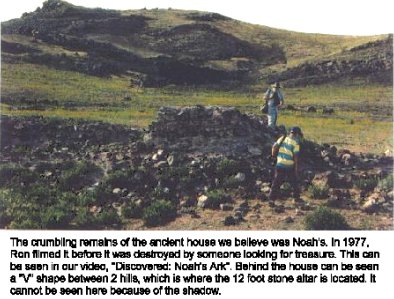
DAY 2 -- The House and Fences
Radiating out from the house was a very large pattern of stone fences which seemed to go on for miles. These too seemed to be covered by several feet of dirt with only the upper part extending above the earth.
When he studied these two large monuments more closely, he noted that on the one lying on the ground, the largest woman - representing Mrs. Noah, had her eyes closed and her head tilted downward. On the larger tombstone which was still standing, he saw that BOTH the first woman AND the first man (Noah) had their eyes closed and heads tilted downward. Since these were in front of the house, he believed they were the actual tombstones of Noah and his wife!
The iconography showed that FIRST Mrs. Noah died, and on her stone only her eyes were closed. When Noah died, BOTH of them were represented as dead.
Ron felt that what he and the boys had found these first two days was extremely important. While they didn't prove anything about the boat-shaped object, there were clear indications that a family of eight people had lived in this exact area during some ancient time. The eight-cross design on the anchor stones showed that someone during the Christian era had identified these huge rocks with the ark and its eight passengers.
The Search for Noah's Ark, part 2
The Fences -- Evidence of Noah's "Husbandry"
- Genesis 9:20-23 "And NOAH BEGAN TO BE AN HUSBANDMAN, and he planted a vineyard: And he drank of the wine, and was drunken; and he was uncovered within his tent. And Ham, the father of Canaan, saw the nakedness of his father, and told his two brethren without. And Shem and Japheth took a garment, and laid it upon both their shoulders, and went backward, and covered the nakedness of their father; and their faces were backward, and they saw not their father's nakedness."
"Husbandry" is defined as "farming, as of livestock" (Random House Dictionary). After the flood, it makes perfect sense that Noah bred the animals and cared for them until the point in time that their numbers were sufficient enough to eliminate the likelihood of their becoming extinct. With only two of each unclean animal, if even one should not survive, that animal would become extinct. And the extremely large pattern of stone fences radiating out from the house, and extending on for a good distance seemed consistent with this type of activity. The depth below the present ground level of the house and fences shows their great antiquity. Over the years, windblown dust and dirt raised the ground level, thus burying or partially burying ancient surface structures.
What Noah Wore
The Giant Altar and Its Complex
This ridge had two small hills which met and formed a valley in between them on the side of this ridge. In the middle of this mountainside valley, Ron saw a VERY large square rock which looked as if it had been deliberately set in that location. Behind this large rock the valley formed a natural amphitheater. On the side of this very large rock was a complex of small fenced-in areas.
- Genesis 8:20 "And Noah built an altar unto the LORD; and took of every clean beast, and of every clean fowl, and offered burnt offerings on the altar."
Also in this complex are two very large stones which display features which indicate that they were used for the slaughter and bleeding of animals. (Genesis. 9:4) One is consistent with the size of smaller animals like sheep and goats; the other, much larger, is consistent with the size of larger animals, such as bullocks. They both have a series of chiseled-out indentions leading from the ground to the flattened, slightly angled top. These indentions are the size that is consistent with animal hooves. Perhaps the animals were led up the side of these rocks to the top, which also contain chiseled out basins with drains, that are consistent with areas for bleeding the animals prior to offering them on the large altar stone. According to the biblical account, specific parts of the animal were offered as sacrifice, then other parts were cooked and eaten "before the Lord." (See Leviticus, chapters 1-9.)
DAY 3- the "Boat-Shaped Object"
Arising the next morning, the boys were tired and stayed in the hotel room. They had traversed across a great number of miles in the previous two days and Ron knew they needed a break. So he got a taxi and returned to the first pile of rocks. They had worked their way backwards from the third pile to the first. And this one was quite a distance from the others.
This time, Ron had the taxi driver take him as far as he could go in the direction that was perpendicular to this rock-pile. They traveled up into the mountain range to the south, as far as there was a dirt road. When it ended, Ron began to walk. With mountains everywhere, he wondered if he would ever be able to spot the boat-shaped object if he looked right at it- but soon he saw it. And what he saw convinced him more than ever that this object was the remains of a ship. But, what he saw also convinced him that there was only one way to explore its true nature, and that was by an excavation to remove the soil which covered it.
He returned to the hotel room and they packed their things. He checked out that night so they could leave early in the morning -- but that proved to be a big mistake. In 1977, there weren't any tourists to speak of in this region. It is desolate and very foreboding. The Kurdish villagers had been watching Ron and the boys, waiting to make their move. As long as they were staying in the hotel, they were spending money -- paying taxis and guides. But these bandits wanted it all, and as soon as they realized Ron was about to leave, they attacked.
It's a long story, but to summarize it, Ron and the boys heard robbers coming up the steps banging pipes and making a lot of noise. Shoving the furniture in front of the door, they tied the bed sheets together and climbed out their third story window onto a roof below. There, they climbed back into the second floor window which led into the kitchen, and they ran through the hotel and out the door.
In the commotion, they lost almost all of their film. Ron did manage to hang on to some of the movie film. Once they were safely out of town, they realized how truly dangerous the region was. The boys would never go there again -- and after all they went through, they would never see the "boat shaped object" in person.
Back at Home -- Now What?
Dr. William Shea
In November of 1978, Ron finally made contact with Dr. Shea, who had written an article about the site in September 1976. He believed that the site should be thoroughly investigated, and when comparing the boat-shaped object to the current thought that the ark HAD to have landed on Mt. Ararat, wrote:
- "To conclude, one might put these two sites in perspective by reflecting upon what would have happened had this formation been found on Agri Dagh [Mt. Ararat]. I may be wrong, but I suspect that news of it [the boat shaped formation] probably would have been heralded far and wide as the discovery of the site where the Ark had rested. What a difference a mountain makes." CREATION RESEARCH SOCIETY QUARTERLY, Volume. 13, September. 1976, "The Ark-Shaped Formation in the Tendurek Mountains of Eastern Turkey," by Dr. William H. Shea.
- "Assuming a Mosaic authorship for these measurements probably would indicate that they were given in terms of the Egyptian cubit of 20.6 inches rather than the shorter Mesopotamian cubit."
Astounding News!
He still remembers how his heart began to pound- HE couldn't excavate, but perhaps "nature's" God had done what he couldn't!
1979 -- Return to Turkey
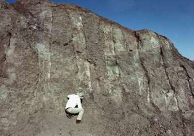
When they arrived at the site, Ron just wasn't prepared for the spectacular sight his eyes beheld -- the earthquake (which injured no one) had dropped the earth around the object and there on the mountainside Ron saw what looked like a giant shipwreck!
He measured the object and got a 512 foot length -- but, he saw what looked like a section about 1 yard long that was broken off from the lower end. This was positive evidence in Ron's eyes: 300 Royal Egyptian cubits were 515 feet- this object was 512 feet with a 3 foot section broken off of the lower end- a total of 515 FEET!
He again inspected the anchor stones and the graveyard which had the strange monuments which Ron believed had representations of the Ark and its eight passengers. It was a short trip, but Ron had accomplished more than he had hoped for. The next step was to have the samples analyzed.
The First Laboratory Analyses
It was another example of positive evidence -- but again, Ron found himself at a standstill.
What next? Applications to excavate were still made, but each time they returned negative replies. Ron was in for an even longer wait this time. But in the meantime, Ron decided to make all his information available to others.
"Noah's Ark Found"
Ron told the story of his two trips to Turkey, what he saw, filmed and photographed, and he gave the lab analyses and told about the tombstones he believed marked the sites of Noah and his wife's graves. He explained about the Royal Egyptian Cubit, which, considering the length of the boat shaped object, he felt was overwhelming evidence.
He gave these to anyone who was interested, hoping to gain interest and support from others who might want to help. But the fact of the matter is, this wasn't enough for some people. In fact, this little booklet would one day be responsible for the theft and destruction of one of the most incredible evidences -- but it was a lesson Ron would have to learn the hard way. Meanwhile, he had no real idea what he could do to further his research.
White's Electronics
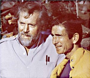
Ron Wyatt and Col. Jim Irwin
Jim was taking an expedition to climb Mt. Ararat in August of 1984, so he and Ron decided to travel together so that Ron could show him the site. They arrived in Istanbul on August 19, 1984 and proceeded to Ankara.
Newsletter July 1994
The Discovery of Noah's Ark
By Mary Nell WyattNOAH'S ARK--The Early Years
ACROSS RED SEA
The Wilderness Has Them Entangled
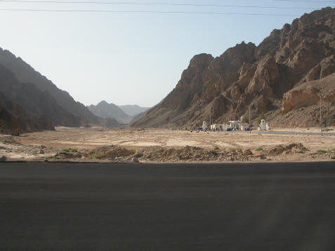
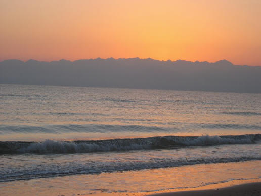
Wadi Watir had the Children of Israel "entangled." Exit point at the large beach at Nuweiba (2005)
When traveling through "the wilderness of the Red Sea" Ex.13:18, escaping Pharaoh's army, God told Moses to turn south, so they headed through a wadi or canyon area that is called the Wadi Watir which led to the sea. The Bible in Ex. 14:3 says, "They are entangled in the land, the wilderness hath shut them in."
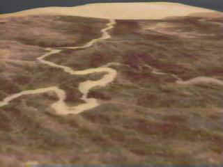
Above, the Wadi Watir winding its way to the Red Sea Crossing site at Nuweiba, had
the children of Israel thinking Moses had made a wrong decision to bring them this way.
the children of Israel thinking Moses had made a wrong decision to bring them this way.
The Beach Where the Crossing Took Place
When arriving at the beach, the children of Israel felt trapped, as they could not turn back, nor head north because at the northern end of the beach was a three story, Egyptian military fortress which is still standing today undergoing restoration.
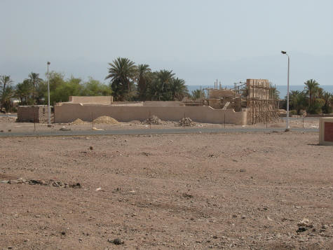
Egyptian military fortress, possibly Migdol, blocked any northern escape route along the beach (photo 2005)
Additionally there were mountains obstructing their escape. To the south the mountains came down to the sea, as mentioned by Josephus, "For there was [on each side] a [ridge of] mountains that terminated at the sea, which were impassable by reason of their roughness, and obstructed their flight" Antiquities of the Jews, Bk. 2, 15-3. You can see the mountains at the beach today. The people were about to turn against Moses because he had led them to an area where they were trapped and would surely die, or so they thought.
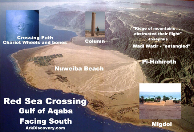
If one looks on a map for a beach area large enough for 2 million people to encamp on the gulf there is only one candidate: Nuweiba Egypt. The beach at Nuweiba is extremely large and could have accommodated a large number of people at the time of Moses. Pi-Hahiroth means, mouth of the hole, which we would apply to the mouth of the canyon above, as mentioned in The Exodus Revealed DVD. Migdol is a fortress, which we would apply to the ancient fort which is located at the narrowest point on the beach where the gulf and the mountains are in close proximity. Today you will find many hotels there and a village.
The Granite Column of Solomon
This column matches one on the other side of the gulf in Saudi Arabia which had the inscriptions intact. The Hebrew words Mizram (Egypt), death, water, pharaoh, Edom, Yahweh, and Solomon were on that column. Apparently one can conclude
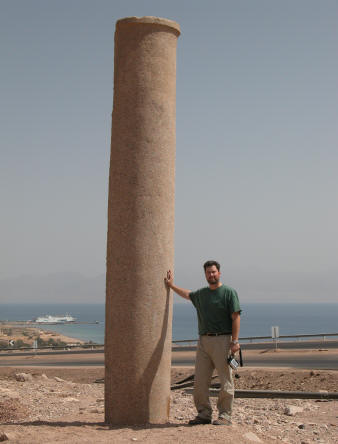
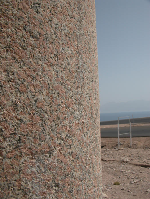

Kevin Fisher at the red granite column, marking the crossing site (Oct. 2005)
King Solomon had these columns erected 400 years after the miracle of the crossing of the Red Sea on dry land. Solomon's sea port was at the northern tip of the Gulf of Aqaba at Eilat (I Kings 9:26) and he was very familiar with the Red Sea crossing site, as it was in his neighborhood. The Bible even mentions this column! Isaiah 19:19, "In that day there will be an altar to the Lord in the midst of the land of Egypt, and a pillar to the Lord at its border." You can visit the beach today and see the column in person, as I was able to do in Oct. 2005.
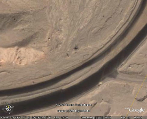
Above we can see the pillar on Google Earth, about 500 feet from the Gulf.
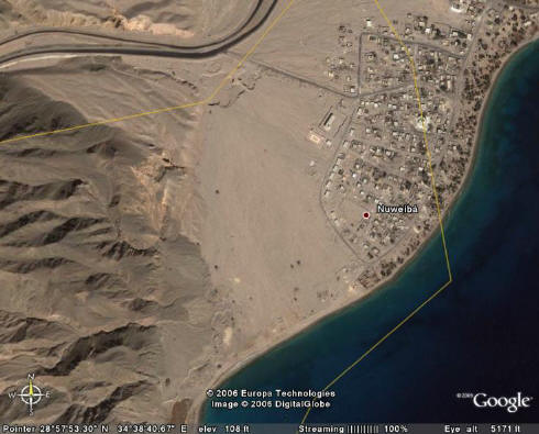
Top of photo shows us where the column is today. The right side has Nuweiba labled
on the Google Earth map. This is the spot where Ron Wyatt found the column
lying at the edge of the water. The name Nuweiba is short for the name listed below:
on the Google Earth map. This is the spot where Ron Wyatt found the column
lying at the edge of the water. The name Nuweiba is short for the name listed below:
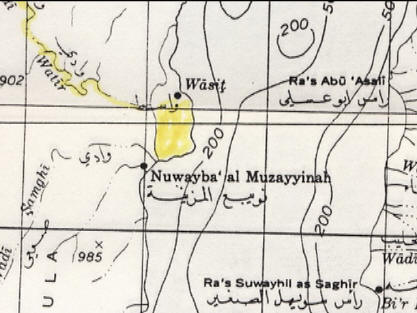
Above, we see the full name Nuwayba' al Muzayyinah which means . . .

Above, Nuwayba' al Muzayyinah means . . . "Waters of Moses Opening"
This is amazing, at the exact spot where the crossing took place, we have
the site confirmed by maps!
This is amazing, at the exact spot where the crossing took place, we have
the site confirmed by maps!
Gradual Contour of Seabed

God caused a strong east wind to blow the waters back so the people could walk ten miles through the Red Sea to safety in Arabia. The crossing path is about a quarter to a half mile wide and is on a gradual slope down to the bottom of the Red Sea and then up to the Saudi beach. On either side of this path are the depths of the Red Sea, the Eilat Deep and the Aragonese Deep, each 3000 and 5000 feet deep respectively.
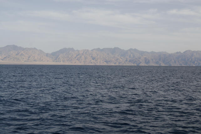
View at Red Sea crossing. Saudi Arabia in distance.
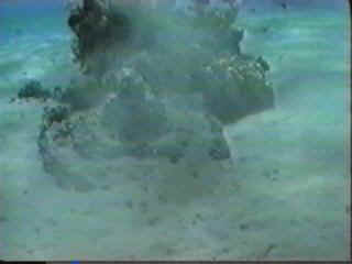
Chariot Wheels Found in the Sea at Nuweiba!
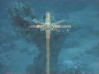
Above, chariot wheels fixed to axels standing at attention on the seabed.
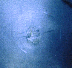
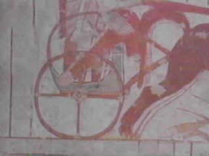
Above, left, photo taken of a gilded chariot wheel that remains on the sea floor. It was found by Ron Wyatt using a molecular frequency generator from his boat above, after he set the equipment to search for gold. The Bible said all the chariots of Egypt and 600 choice chariots, or gold veneered models, were in the army pursuing God's people. It is speculated there were 20,000 chariots destroyed that day. Above, right, is a drawing of a four spoke chariot found in an Egyptian tomb from the same time period. Four, six and eight spoke wheels are found here in the gulf, and were only used at the same time during the 18th dynasty or 1446 BC when the exodus took place.


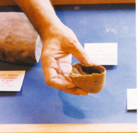
There are numerous chariot wheels, plus human and horse bones at the crossing site. Above on right, is a human femur bone that is covered by coral, and was tested at Stockholm University. It is from the right leg of a man 165-170cm tall. It is basically mineralized by resting in the Red Sea for such a long time.
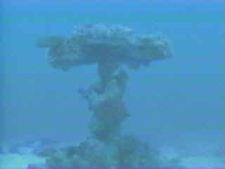
Above is a coral covered chariot wheel on a vertical axel that is buried in the sand. Although this is atypical, a diver found this within 10 minutes of searching at Nuweiba
Above is a horse's hoof that is shrunken since drying out. Horses are not found in the
Sinai Peninsula today
Sinai Peninsula today
___________________________________________________
Visit Nuweiba Egypt at the Red Sea Crossing
Stay at SwissCare Hotel
Stay at SwissCare Hotel
http://www.swisscare-hotels.com/
They can pick you up at Cairo airport or at Taba border crossing at Eilat, Israel
They can pick you up at Cairo airport or at Taba border crossing at Eilat, Israel
____________________________________________________
Mt. Sinai Must be in Saudi Arabia!
Above: We look across the Gulf of Aqaba and see the mountains of Saudi Arabia and know that Mt. Sinai MUST be in there, not in the Sinai Peninnsula
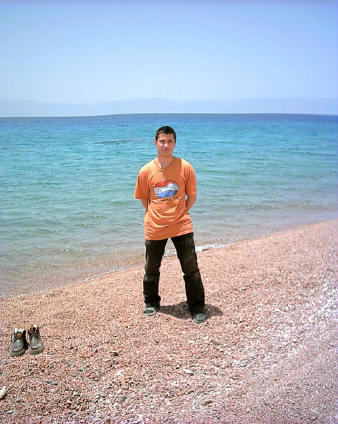
Above - Aaron Sen stands on the Saudi Arabian beach opposite Nuweiba. The chariot wheel below was found in these Saudi Arabian waters. Aaron's web site is http://www.wyattarchaeology.com/
Above, round chariot wheel found off the Gulf of Aqaba coast of Saudi Arabia, opposite of Nuweiba, Egypt. (photo Viveka Ponten and The Exodus Revealed DVD)
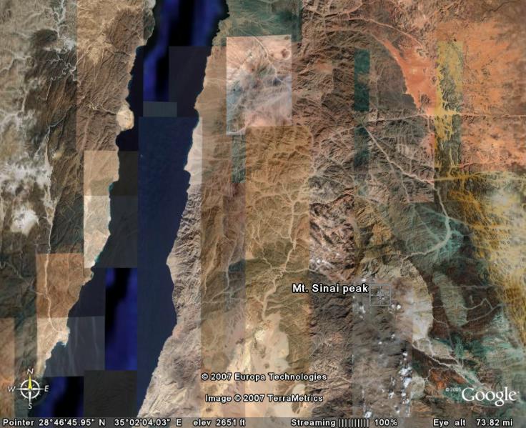
Above we see the crossing site at the large beach, and we see the real Mt. Sinai in the lower right
in Saudi Arabia, in Midian, named Jebel el Lawz.
in Saudi Arabia, in Midian, named Jebel el Lawz.
Documentary coming out in 2010 on this discovery and
the real Mt. Sinai! Multi-million dollar production
See http://www.exodusconspiracy.com/
View their video library!
the real Mt. Sinai! Multi-million dollar production
See http://www.exodusconspiracy.com/
View their video library!
Subscribe to:
Posts (Atom)